PrintDates

Try “bears”, “hallmark”, “AP exams” or “moon 2027”.

Tides, Florida

Charlotte Harbor tide chart tide times and a printable month

Punta Gorda, NOAA station 8725744 Times in ET Feet above mean lower low water

Tides today Tuesday, October 13

3:54a12:01p6:45p10:36p
  • High 3:54 AM 2.3 ft
  • Low 12:01 PM 0.2 ft
  • High 6:45 PM 1.5 ft
  • Low 10:36 PM 1.3 ft
  • Sunrise7:26 AM
  • Sunset7:01 PM

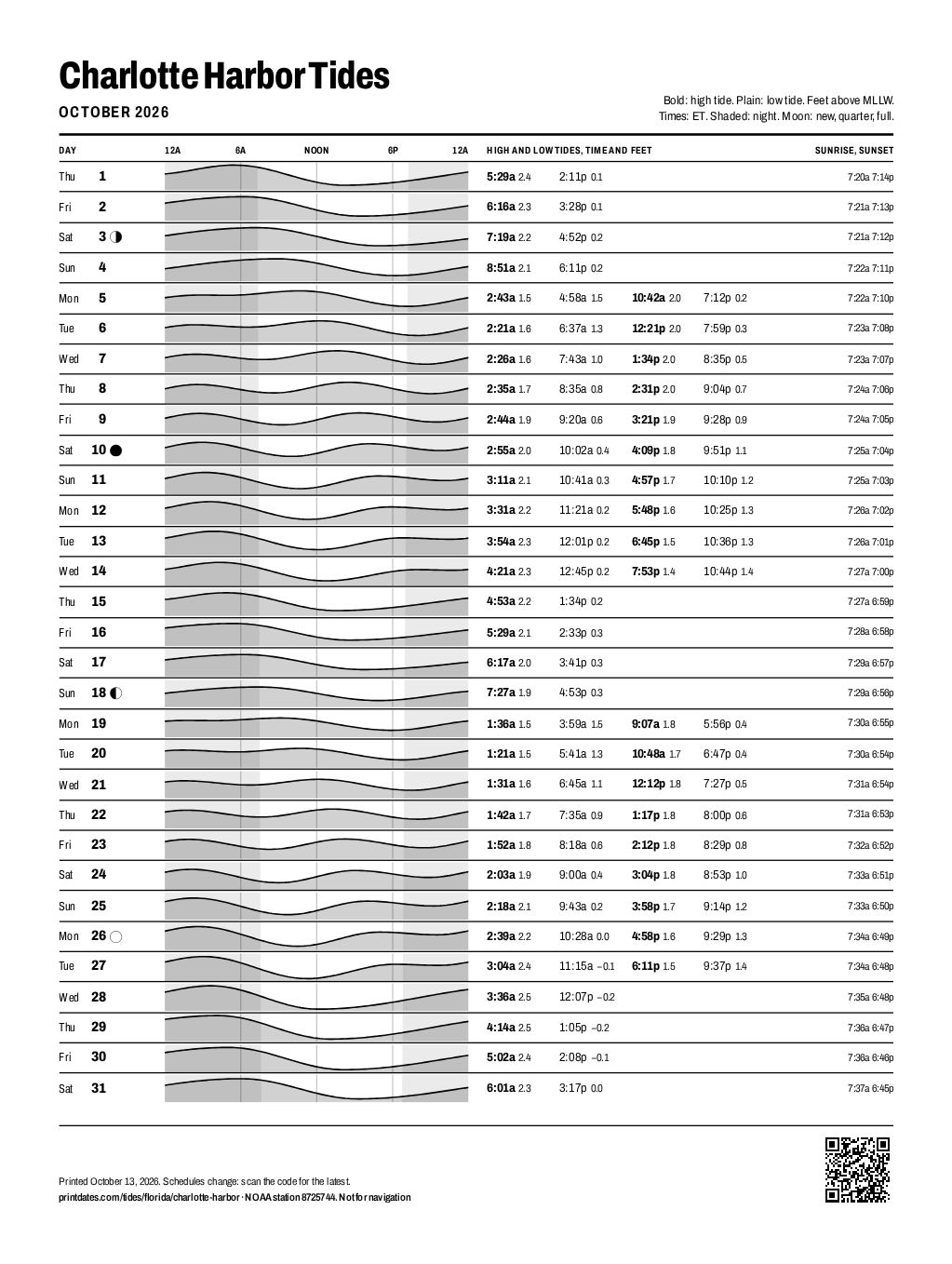
Charlotte Harbor Tides

October 2026

Bold: high tide. Plain: low tide. Feet above MLLW.

Times: ET. Shaded: night. Moon: new, quarter, full.

  1. Thu 1 High5:29a 2.4Low2:11p 0.1 7:20a 7:14p
  2. Fri 2 High6:16a 2.3Low3:28p 0.1 7:21a 7:13p
  3. Sat 3 Last quarter High7:19a 2.2Low4:52p 0.2 7:21a 7:12p
  4. Sun 4 High8:51a 2.1Low6:11p 0.2 7:22a 7:11p
  5. Mon 5 High2:43a 1.5Low4:58a 1.5High10:42a 2.0Low7:12p 0.2 7:22a 7:10p
  6. Tue 6 High2:21a 1.6Low6:37a 1.3High12:21p 2.0Low7:59p 0.3 7:23a 7:08p
  7. Wed 7 High2:26a 1.6Low7:43a 1.0High1:34p 2.0Low8:35p 0.5 7:23a 7:07p
  8. Thu 8 High2:35a 1.7Low8:35a 0.8High2:31p 2.0Low9:04p 0.7 7:24a 7:06p
  9. Fri 9 High2:44a 1.9Low9:20a 0.6High3:21p 1.9Low9:28p 0.9 7:24a 7:05p
  10. Sat 10 New moon High2:55a 2.0Low10:02a 0.4High4:09p 1.8Low9:51p 1.1 7:25a 7:04p
  11. Sun 11 High3:11a 2.1Low10:41a 0.3High4:57p 1.7Low10:10p 1.2 7:25a 7:03p
  12. Mon 12 High3:31a 2.2Low11:21a 0.2High5:48p 1.6Low10:25p 1.3 7:26a 7:02p
  13. Tue 13 High3:54a 2.3Low12:01p 0.2High6:45p 1.5Low10:36p 1.3 7:26a 7:01p
  14. Wed 14 High4:21a 2.3Low12:45p 0.2High7:53p 1.4Low10:44p 1.4 7:27a 7:00p
  15. Thu 15 High4:53a 2.2Low1:34p 0.2 7:27a 6:59p
  16. Fri 16 High5:29a 2.1Low2:33p 0.3 7:28a 6:58p
  17. Sat 17 High6:17a 2.0Low3:41p 0.3 7:29a 6:57p
  18. Sun 18 First quarter High7:27a 1.9Low4:53p 0.3 7:29a 6:56p
  19. Mon 19 High1:36a 1.5Low3:59a 1.5High9:07a 1.8Low5:56p 0.4 7:30a 6:55p
  20. Tue 20 High1:21a 1.5Low5:41a 1.3High10:48a 1.7Low6:47p 0.4 7:30a 6:54p
  21. Wed 21 High1:31a 1.6Low6:45a 1.1High12:12p 1.8Low7:27p 0.5 7:31a 6:54p
  22. Thu 22 High1:42a 1.7Low7:35a 0.9High1:17p 1.8Low8:00p 0.6 7:31a 6:53p
  23. Fri 23 High1:52a 1.8Low8:18a 0.6High2:12p 1.8Low8:29p 0.8 7:32a 6:52p
  24. Sat 24 High2:03a 1.9Low9:00a 0.4High3:04p 1.8Low8:53p 1.0 7:33a 6:51p
  25. Sun 25 High2:18a 2.1Low9:43a 0.2High3:58p 1.7Low9:14p 1.2 7:33a 6:50p
  26. Mon 26 Full moon High2:39a 2.2Low10:28a 0.0High4:58p 1.6Low9:29p 1.3 7:34a 6:49p
  27. Tue 27 High3:04a 2.4Low11:15a −0.1High6:11p 1.5Low9:37p 1.4 7:34a 6:48p
  28. Wed 28 High3:36a 2.5Low12:07p −0.2 7:35a 6:48p
  29. Thu 29 High4:14a 2.5Low1:05p −0.2 7:36a 6:47p
  30. Fri 30 High5:02a 2.4Low2:08p −0.1 7:36a 6:46p
  31. Sat 31 High6:01a 2.3Low3:17p 0.0 7:37a 6:45p
Printed October 13, 2026. Schedules change: scan the code for the latest.

printdates.com/tides/florida/charlotte-harbor · NOAA station 8725744. Not for navigation

Tides this week

DayHigh and low tides (ET)
Tue Oct 13
  • High 3:54 AM 2.3 ft
  • Low 12:01 PM 0.2 ft
  • High 6:45 PM 1.5 ft
  • Low 10:36 PM 1.3 ft
Wed Oct 14
  • High 4:21 AM 2.3 ft
  • Low 12:45 PM 0.2 ft
  • High 7:53 PM 1.4 ft
  • Low 10:44 PM 1.4 ft
Thu Oct 15
  • High 4:53 AM 2.2 ft
  • Low 1:34 PM 0.2 ft
Fri Oct 16
  • High 5:29 AM 2.1 ft
  • Low 2:33 PM 0.3 ft
Sat Oct 17
  • High 6:17 AM 2.0 ft
  • Low 3:41 PM 0.3 ft
Sun Oct 18
  • High 7:27 AM 1.9 ft
  • Low 4:53 PM 0.3 ft
Mon Oct 19
  • High 1:36 AM 1.5 ft
  • Low 3:59 AM 1.5 ft
  • High 9:07 AM 1.8 ft
  • Low 5:56 PM 0.4 ft
Charlotte Harbor tide chart for October 2026: every high and low tide on one printable page
The printed page, as the PDF prints it. Save to Pinterest

About these tides

These are NOAA's predictions for Punta Gorda (station 8725744), about 3.3 km from Charlotte Harbor. NOAA works them out from St. Petersburg (station 8726520), shifting its tides by fixed amounts measured for this spot, so expect them to be a little less exact than at a primary station. Times are local, with daylight saving time when it applies. Heights are in feet above mean lower low water (MLLW), the average of each day's lower low tide, which is why a low tide can be below zero.

Predictions follow the moon and sun. Wind, air pressure, rain and storms can make the real tide earlier, later, higher or lower, sometimes by a lot. Use them to plan a walk on the beach, not to navigate.

Source: NOAA Tides and Currents (tidesandcurrents.noaa.gov), last checked Tuesday, October 13. NOAA revises its predictions a few times a year; this page follows. Sunrise and sunset are calculated for the station.